
BERTRAND DAILY REPORT The War For Your Mind and Soul Continues
Subject: Low Flying NASA DC-8 Near Los Angeles Spurs Conspiracy Theories, But Missed The "Big One."--Videos
Let's dispel the latest myths that NASA's low flying DC-8 (series 72) is a "secret operation" [creating tremors] as the flight plan follows fault lines from Los Angeles to areas east of Boise Idaho recently. And NO....It's not "Dave Bertrand on a suicide mission." [fools]
The only low flying I've done in a DC-8 (series 62) was over the jungles of Brazil at 500 feet at ~350mph in uncontrolled airspace.
NASA's flying airborne laboratory is mapping underground movements of magma and has been for years. Only recently, the hysteria is reaching the point of ridiculous.
But what should be more scarier than that.....the airborne laboratory has detected an unusual (but predicted) movement of magma and tremors towards two very sensitive and major fault line (potential) epicenters. "A first" according to scientists...
The Garlock Fault is the one to watch, southeast of the July 4th Ridgecrest earthquake.....could easily release an 8.0 or higher. Some scientists believe possibly up to a 9.0..... causing a "1,000 times more devastation than the July 4th earthquake" of which the Ridgecrest has recorded over 80,000 small quakes so far.
But not to worry.....the chance of the "Big One" expected to separate California from the Union is a 1:300 chance anytime soon. God has a way of solving problems....
---Dave Bertrand
"The Ridgecrest aftershocks have also headed southeast toward the Garlock fault, a lesser-known fault capable of producing an earthquake of magnitude 8 or more. The fault along the northern edge of the Mojave Desert can send shaking south and west into Bakersfield and Ventura and Los Angeles counties."
Example of NASA's DC-8 Research
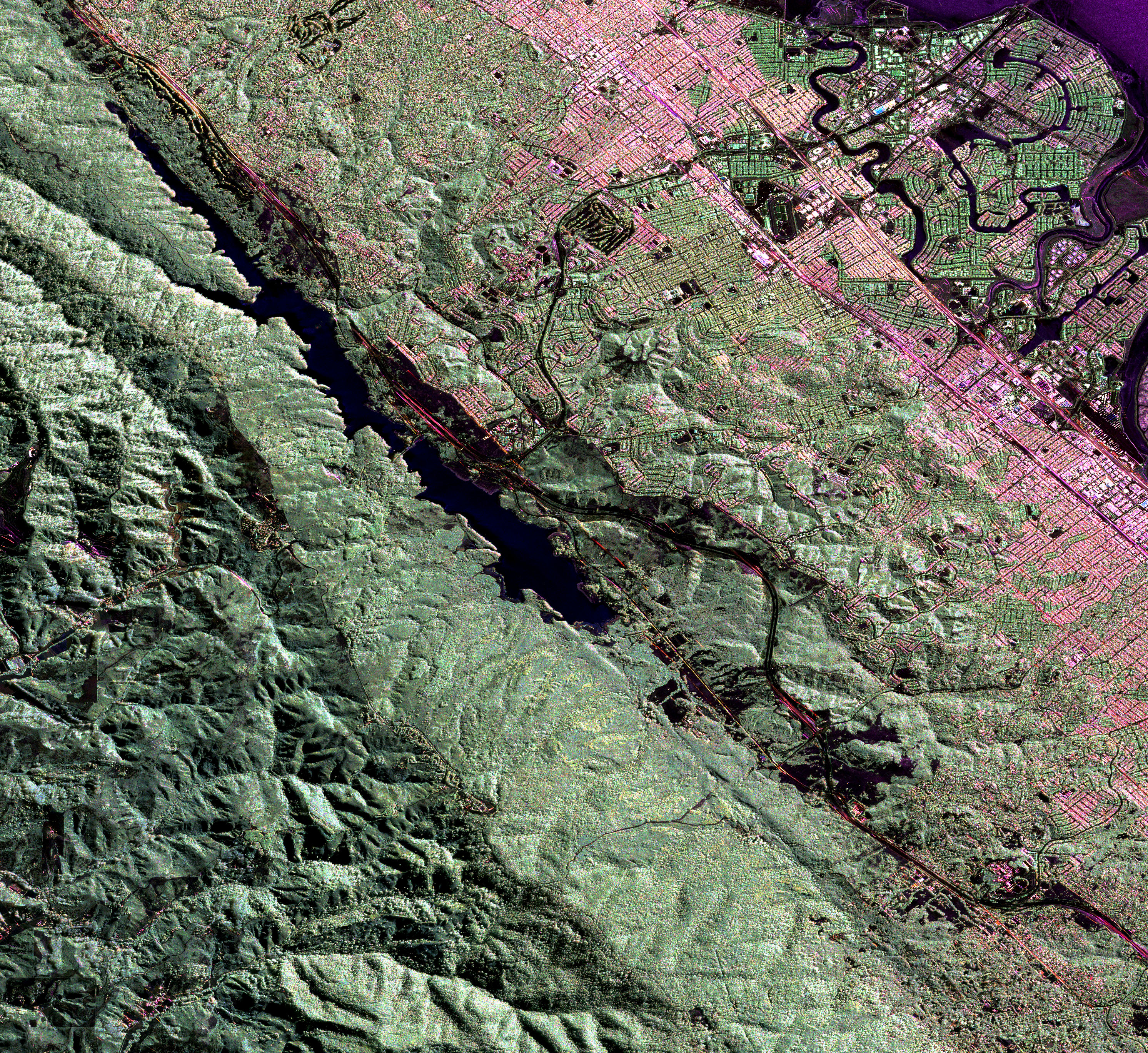
"The image (below) was captured in November 2008 as part of a campaign to repeatedly collect detailed, three-dimensional images of the San Andreas Fault along the same flight path. The goal is to map which parts of the fault are creeping past each other with little “stickiness,” and which parts appear to be locked together—places where pent-up stress may be released suddenly in a major earthquake. By repeatedly collecting images over an identical flight track, scientists can spot places where the topography is visibly deformed. Ground deformation—sometimes just a fraction of inch—can indicate that far below the surface, the plates are stuck together."
Conspiracy Theories About Low Flying DC-8 Totally Whacked-out !
NASA FLIES PLANE EXTREMELY LOW OVER LOS ANGELES
|
NASA DC-8 Science Instrument Checkout Flight for Operation IceBridge
|
Over 80,000 Quakes Have Hit California Since July 4th, Aftershocks Headed "Toward The Garlock Fault"
by Tyler Durden
First of all, the Garlock fault is the second largest fault line in the entire state of California, and it is a major threat to southern California.
Secondly, the Garlock fault runs directly into the San Andreas fault, and many believe that a major quake along one could potentially trigger a major quake along the other.
If you are not familiar with the Garlock fault, the following is some basic information from Wikipedia…
The Garlock Fault marks the northern boundary of the area known as the Mojave Block, as well as the southern ends of the Sierra Nevada and the valleys of the westernmost Basin and Range province. Stretching for 250 kilometers (160 mi), it is the second-longest fault in California and one of the most prominent geological features in the southern part of the state.The Garlock Fault runs from a junction with the San Andreas Faultin the Antelope Valley, eastward to a junction with the Death Valley Fault Zone in the eastern Mojave Desert. It is named after the historic mining town of Garlock, founded in 1894 by Eugene Garlock and now a ghost town.
So exactly what would a major quake along the Garlock fault look like?
Here is how the Los Angeles Times described what a “worst-case scenario” would look like…
A worst-case scenario would be a magnitude 7.7 earthquake that begins on the eastern end of the Garlock fault in eastern San Bernardino County and unlocks the fault to the southwest, bringing severe shaking to towns such as California City and Tehachapi; Edwards Air Force Base and Lancaster would see very strong shaking. Even Santa Clarita and the San Fernando Valley would see strong shaking, with much of the L.A. Basin and the San Gabriel Valley seeing moderate shaking — worse than what L.A. encountered last week.
No, that is definitely not a “worst-case scenario” for the Garlock fault, but without a doubt a major quake along the fault would be far more destructive than the earthquakes that we just witnessed on July 4th and 5th.
We were told that those earthquakes “did not cause much damage”, but now we are learning that those quakes actually “caused an estimated $200 million in damage”…
The powerful earthquake that rocked California earlier this month caused an estimated $200 million in damage.The cost of damage from the magnitude 7.1 earthquake that hit southeastern California on July 5 and foreshocks that came a day earlier was estimated by catastrophe modeling business Karen Clark & Company.
So if relatively minor earthquakes can cause that much economic damage, what would an earthquake 1,000 times more powerful do?
Because someday “the Big One” is going to hit the San Andreas fault, and it is going to release so much energy that the quakes that we witnessed this month won’t even be worth comparing to it. In fact, if a magnitude 9.1 earthquake were to hit southern California, it would be exactly 1000 times more powerful than the magnitude 7.1 quake that happened back on July 5th.
And even though it isn’t likely, scientists did admit that the large earthquakes that happened earlier this month could trigger a quake on the San Andreas fault…
Scientists knew almost immediately that two large quakes that hit near Ridgecrest earlier this month did not come from the San Andreas. But ever since, they’ve been studying whether the quakes could cause more seismic activity from other faults — including the San Andreas nearly 100 miles away. A new calculation conducted in recent weeks at the U.S. Geological Survey showed that there’s an extremely remote chance the San Andreas could be triggered from the Ridgecrest quakes.
Hopefully it will not happen any time soon, but seismologists assure us that it is only a matter of time before “the Big One” strikes California. They have repeatedly warned us that the San Andreas fault is “locked and loaded” and that it has the potential to “unzip all at once”.
And when that day finally arrives, scientists have determined that the ground level could drop by up to 3 feet, and that would result in vast portions of southern California suddenly being covered by the Pacific Ocean.
READ MORE......................
https://www.zerohedge.com/
SEE ALSO..........................
24. Douglas DC-8 Cockpit - Global Mighty Freight Dog! (Trailer)
|
From the Desk of Capt. Dave Bertrand (Ret.) Your Comments Are Welcomed and Can Be Published Unless You Specify Otherwise.
Retired Int'l Freight Captain (DC-8 & B-727), Former (State) Law Enforcement, U.S. Customs (UC) Miami Sector, US Army Military Police Veteran, Former Int'l Aircraft Repo Insurance Contractor, Embry Riddle Aeronautical University & University of Alaska (Undergraduate), Interests include Border Security, 9/11 Truth, Government Corruption, New World Order, Freedom vs Communism, Secret Space Programs & UFO Encounters, Aviation, and Enjoy Living Off-The-Grid.
Read Past Bertrand Daily Reports: https://
No comments:
Post a Comment